Saarivaaran kuvaus
Saarivaara - runon ja rajan kylä
Saarivaara on Joensuun eteläisin kylä. Se sijaitsee Tohmajärven vastaisella rajalla nykyisen valtakunnan rajan tuntumassa noin 80 kilometriä Joensuun keskustaajamasta. Venäjän puolelle jääneeseen, nykyisin tyhjillään olevaan Korpiselän kirkonkylään on matkaa noin 15 kilometriä.
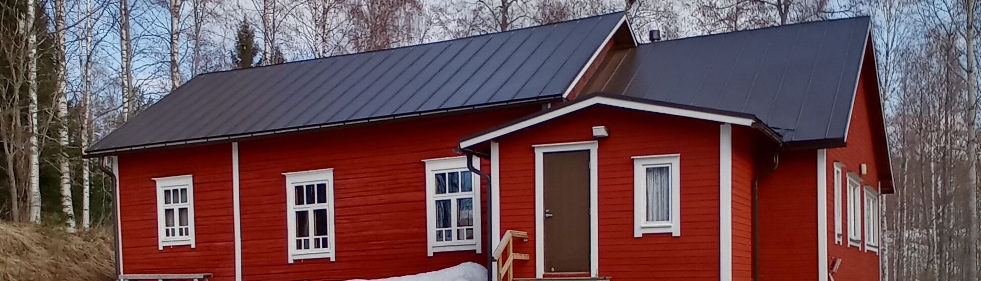
Saarivaara edustaa perinteistä vaarakylämaisemaa, joka on rakentunut vaarojen rinteille ja niiden päälle. Saarivaara on luokiteltu maakunnallisesti arvokkaaksi maisema-alueeksi. Osa ennen avoimista maisemista on kuitenkin valitettavasti jo pusikoitunut ja metsittynyt, kun maanviljelys ja karjanhoito ovat vähentyneet. Avohakkuut ovat myös vaikuttaneet maisemanäkymiin. Kylän maisemat ovat kauniita ja täkäläinen luonto on rikasta. Luonnossa ja ilmastossa näkyy Laatokan vaikutus.
Merkittäviä rakennuksia kylällä ovat yli 100 vuotta vanha nuorisoseurantalo, vuonna 1976 rakennettu tsasouna ja nykyisin yksityiskäytössä oleva kyläkoulu. Kanajärven rannalla on hyvä hiekkapohjainen uimapaikka. Kylän läpi kulkee Via Karelia -tie.
Vakituisia asukkaita kylässä oli 22 vuonna 2024. Nuorisoseura Sarastuksen toimesta kyläläisille ja kesäasukkaille järjestetään talkootyönä monenlaisia tapahtumia ja toimintaa, johon ovat tervetulleita myös naapurikylien asukkaat. Talvisin kylän ympäri kiertää 7 kilometrin hiihtolatu. Tuupovaaran moottorikerhon ylläpitämän kodan kautta kulkee kelkkaura etelään Värtsilään ja pohjoiseen Tuupovaaraan ja Ilomantsiin. Kylässä on myös sotahistoriallinen muistomerkki 11. Divisionaan ja erityisesti jalkaväkirykmentti 8:n vaiheista toisessa maailmansodassa. Väinö Linnan Tuntematon Sotilas -kirjassa on kuvaus juuri tästä paikasta.
Elokuun 5. ja 6. päivä vietetään joka vuosi Spuassan praasniekkaa ristisaattoineen. Vuonna 1976 käyttöön vihitty tsasouna on pyhitetty Herran kirkastumisen päivän muistolle. Kesällä 2023 tsasounan pihalle pystytettiin Kanajärven Kalmoniemen kalmiston muisteluristi.
Saarivaaran historia
Saarivaara on entisen Korpiselän kunnan kylä, jonka itäosa luovutettiin Neuvostoliitolle vuonna 1944. Kylän Suomen puolelle jäänyt osa kuuluu nykyisin Joensuun kaupunkiin.
Korpiselkä oli harvaan asuttua ”runojen ja metsien” Karjalaa. Runsaat vesistöt, suot, vaarat, hiekkasärkät sekä erityisesti Tolvajärven harjut antoivat oman erityispiirteensä Korpiselälle ja sen luonnolle. Suomen itsenäistyessä 1917 Vanha Suomi ja sen mukana Korpiselkä jäi Suomen puolelle. Itsenäisyyden ajan rajat eivät kuitenkaan säilyneet kuin parikymmentä vuotta. Talvi- ja jatkosodan aikana Korpiselän alueella käytiin kovia taisteluja. Sotien jälkeinen uusi raja jakoi Korpiselän kunnan niin, että 93 prosenttia koko kunnan pinta-alasta jäi Neuvostoliiton puolelle. Korpiselän kirkonkylä kirkkoineen ja hautausmaineen jäi uuden rajan itäpuolelle noin kahden kilometrin päähän rajasta. Suomen puolelle jäi vain 110 km2 käsittävä Korpiselän läntisin osa, jota on myöhemmin alettu kutsua nimellä Tynkä-Korpiselkä. Alueella on Ruhovaaran, Mannervaaran, Hoilolan, Saaroisten sekä Meriinahon ja Saarivaaran kylät tai vain osia niistä.
Ennen alueluovutuksia Saarivaaran kautta kulki maantie Korpiselän kirkonkylästä Värtsilään. Moskovan rauhan raja jätti Saarivaaran ja muut Korpiselän Suomen puolelle jääneet kylät ilman tieyhteyttä muuhun Suomeen, sillä maantien Korpiselkä-Hoilola-Saarivaara-Värtsilä molemmat päät jäivät luovutetulle alueelle. Sotien jälkeen tieyhteydet paranivat, kun Hoilolan ja Öllölän välille valmistui tie 1948 ja Saarivaaran ja Suomen puolelle jääneen Värtsilän välinen tie valmistui.
Saarivaara oli aiemmin yksi Suomen parhaiten vartioiduista maaseutukylistä, sillä sitä vartioivat sekä omat että naapurimme Venäjän rajavartijat. Kummallakin oli omat vartiotorninsa.
Kotikyläni
Kotikyläni kaunis, kaunis oot niin,
sua vaihtais en maallisiin aarteisiin.
Kun hiihtelen vaaroillas kimaltavilla,
tai käyskelen kesäisin rantamilla
aina sydämen täyttää kiitollisuus,
syvä rauha ja onnellisuus.
On paikka mullakin maailmassa,
pien kolkka Suomessa armahassa.
Tää on entistä Laatokan Karjalaa
ja osa on jäänyt rajan taa.
Silti Karjalan kunnailla laulu soi,
ja paljosta, paljosta kiittää voi.
Tämän kylän kauneus lumoaa, ja ihmisen inspiroi, innoittaa.
Täältä aiheita löytyisi moneenkin lauluun,
tai miksi ei myöskin tauluun.
Näillä kauniilla vaaroilla kotini on,
oisko mitään syytä olla onneton?
Hyvät naapurit löytyvät kylästä tästä.
- Mitä puuttuisi vielä elämästä?
Saarivaara - kylä armainen,
kuvas talletan pohjaan sydämen.
Ja Luojalta pyydän - rukoilen,
säilytä rauha rajojen.
- Anja Muranen -
Saarivaara - The village of poetry and borders
Saarivaara is the southernmost village in Joensuu, locating about 80 kilometres from the centre of Joensuu. Its neighbours are the municipality of Tohmajärvi in the south and the Russian state in the east. The former Korpiselkä municipality centre of Saarivaara is about 15 kilometres away, currently on the Russian side, and is at present empty.
Saarivaara represents a traditional forested hill village landscape, with villages built on and around the slopes of hills. Saarivaara is classified as a landscape area of provincial importance. Unfortunately, however, parts of the formerly open landscape have now become bushy and wooded as farming and livestock farming have declined. Clear-cutting in the forests has also affected landscape views. However, the village has beautiful landscapes and a rich natural environment. The climate and natural environment is influenced by the Lake Ladoga.
Notable buildings in the village include a more than 100-year-old youth clubhouse, a chapel built in 1976 and the village school, which is currently in private use. There is a good sandy bathing area on the shore of Lake Kanajärvi. The Via Karelia road runs through the village.
In 2024, the village had 22 permanent residents. The Youth Association Sarastus of the village organises a wide range of events and activities for the villagers and summer residents. The events are also open to the residents of neighbouring villages. In winter, a 7-kilometre cross-country ski trail runs around the village. The Tuupovaara Motor Club maintains a snowmobile path to the south to Värtsilä and to the north to Tuupovaara and Ilomantsi. The village also has a war memorial to the 11th Division, and in particular to Infantry Regiment 8, based on the historical events during the Second World War. Väinö Linna's book The Unknown Soldier contains a description of this very place.
Every year on 5 and 6 August, the Spuassa village festival is celebrated with an orthodox cross ceremony. Inaugurated in 1976, the village chapel is dedicated to the day of the Lord's Transfiguration. In the summer of 2023, a memorial cross was erected in the courtyard of the Chapel for the memory of the former Kalmoniemi Cemetery of Kanajärvi.
About the history of Saarivaara
Saarivaara is a village of the former Korpiselkä municipality, the eastern part of which was handed over to the Soviet Union as a result of the Second World War. The Finnish part of the village is now part of the city of Joensuu.
Korpiselkä belonged to the sparsely populated Karelia of "poems and forests". The abundance of water bodies, swamps, forested hills, sandbanks and especially the ridges of Tolvajärvi gave Korpiselkä and its nature its own special character. When Finland became independent in 1917, the so-called "Old Finland" and Korpiselkä with it remained on the Finnish side. However, the borders of the independence period did not remain intact for more than twenty years. During the Winter and Continuation Wars, fierce battles were fought in the Korpiselkä area. The new post-war border divided the municipality of Korpiselkä so that 93% of the total area of the municipality now remains on the Soviet side. The centre of Korpiselkä municipality with its churches and cemetery remained on the eastern side of the new border, about two kilometres from the border. Only the westernmost part of Korpiselkä, covering 110 km2, remained on the Finnish side, which later came to be called Tynkä-Korpiselkä (Stub-Korpiselkä). The area in Finland includes the villages of Ruhovaara, Mannervaara, Hoilola, Saaroinen, Meriinaho and Saarivaara, or only parts of them.
Before the territorial cessions, the road from Korpiselkä to Värtsilä ran through Saarivaara. The new border left Saarivaara and other villages on the Finnish side of Korpiselkä without road access to the rest of Finland, as both ends of the road from Korpiselkä to Värtsilä via Hoilola and Saarivaara remained in the ceded territory in the Soviet Union. After the war, road connections improved with the completion of the road between Hoilola and Öllölä in 1948 and with the completion of the road between Saarivaara and that part of Värtsilä which remained on the Finnish side.
Saarivaara used to be one of the best-guarded rural villages in Finland, guarded by both our own and our neighbouring Russian border guards. Both had their own watchtowers in the area.
My home village
My home village beautiful, beautiful you are,
I wouldn't trade you for earthly treasures.
When I ski on the glittering hills,
when I visit the beaches in summer,
my heart is always filled with gratitude,
deep peace and happiness.
There is a place for me in the world,
a small corner in the cherished Finland.
This is the former Ladoga Karelia,
with parts of it beyond the border.
Still you can hear the Karelian hills singing,
and there is much, much to be thankful for.
The beauty of this village is enchanting and inspiring.
Here you could find themes for many a song,
or why not for a painting, too.
These are the beautiful hills of my home,
so should there be any reason to be unhappy?
Good neighbours can be found in the village here.
- What could be missing in life?
Saarivaara - a cherished village,
I'll put your picture in the bottom of my heart.
And I ask the Creator - I pray,
keep the peace of the borders.
- Anja Muranen -